


Colorado
Colorado
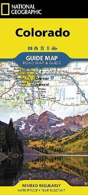
- Waterproof - Tear-Resistant - Travel MapNational Geographic's Colorado Guide Map is designed to meet the needs of travelers with detailed and accurate cartography and loads of helpful information about the state's many attractions. Cities and towns are easy to find with the map's helpful index. Highways, roadways, toll roads, scenic routes, and other roads are clearly designated. Distances in miles are noted on major highways so travelers can easily plan their best route. Hundreds of points of interest are shown, along with national and state parks, public campsites, visitor information centers, airports, ski areas, hospitals, and more.Inset maps of Denver, Colorado Springs, Pueblo, Fort Collins, Mesa Verde National Park, and Rocky Mountain National Park provide greater detail of key areas of the state. A map of the San Juan Skyway highlights one of Colorado's many scenic drives. The information provided about points of interest, Denver, and Rocky Mountain and Mesa Verde national parks will help you take advantage of many sites and recreation activities the state has to offer. A handy chart of park service sites and climate information are also included.Every State Guide Map is printed on durable synthetic paper, making them waterproof, tear-resistant and tough -- capable of withstanding the rigors of any kind of travel.Map Scale = 1:1,584,000Sheet Size = 17.75" x 20.75"Folded Size = 4" x 8.75"
- Waterproof - Tear-Resistant - Travel MapNational Geographic's Colorado Guide Map is designed to meet the needs of travelers with detailed and accurate cartography and loads of helpful information about the state's many attractions. Cities and towns are easy to find with the map's helpful index. Highways, roadways, toll roads, scenic routes, and other roads are clearly designated. Distances in miles are noted on major highways so travelers can easily plan their best route. Hundreds of points of interest are shown, along with national and state parks, public campsites, visitor information centers, airports, ski areas, hospitals, and more.Inset maps of Denver, Colorado Springs, Pueblo, Fort Collins, Mesa Verde National Park, and Rocky Mountain National Park provide greater detail of key areas of the state. A map of the San Juan Skyway highlights one of Colorado's many scenic drives. The information provided about points of interest, Denver, and Rocky Mountain and Mesa Verde national parks will help you take advantage of many sites and recreation activities t
PRP: 67.59 Lei
Acesta este Pretul Recomandat de Producator. Pretul de vanzare al produsului este afisat mai jos.
60.83Lei
60.83Lei
67.59 LeiPrimesti 60 puncte

Indisponibil
Descrierea produsului
- Waterproof - Tear-Resistant - Travel MapNational Geographic's Colorado Guide Map is designed to meet the needs of travelers with detailed and accurate cartography and loads of helpful information about the state's many attractions. Cities and towns are easy to find with the map's helpful index. Highways, roadways, toll roads, scenic routes, and other roads are clearly designated. Distances in miles are noted on major highways so travelers can easily plan their best route. Hundreds of points of interest are shown, along with national and state parks, public campsites, visitor information centers, airports, ski areas, hospitals, and more.Inset maps of Denver, Colorado Springs, Pueblo, Fort Collins, Mesa Verde National Park, and Rocky Mountain National Park provide greater detail of key areas of the state. A map of the San Juan Skyway highlights one of Colorado's many scenic drives. The information provided about points of interest, Denver, and Rocky Mountain and Mesa Verde national parks will help you take advantage of many sites and recreation activities the state has to offer. A handy chart of park service sites and climate information are also included.Every State Guide Map is printed on durable synthetic paper, making them waterproof, tear-resistant and tough -- capable of withstanding the rigors of any kind of travel.Map Scale = 1:1,584,000Sheet Size = 17.75" x 20.75"Folded Size = 4" x 8.75"
- Waterproof - Tear-Resistant - Travel MapNational Geographic's Colorado Guide Map is designed to meet the needs of travelers with detailed and accurate cartography and loads of helpful information about the state's many attractions. Cities and towns are easy to find with the map's helpful index. Highways, roadways, toll roads, scenic routes, and other roads are clearly designated. Distances in miles are noted on major highways so travelers can easily plan their best route. Hundreds of points of interest are shown, along with national and state parks, public campsites, visitor information centers, airports, ski areas, hospitals, and more.Inset maps of Denver, Colorado Springs, Pueblo, Fort Collins, Mesa Verde National Park, and Rocky Mountain National Park provide greater detail of key areas of the state. A map of the San Juan Skyway highlights one of Colorado's many scenic drives. The information provided about points of interest, Denver, and Rocky Mountain and Mesa Verde national parks will help you take advantage of many sites and recreation activities t
Detaliile produsului
De pe acelasi raft
-

PRP: 154.94 Lei
139.45 Lei
139.45 Lei154.94 Lei
-
PRP: 331.43 Lei
298.29 Lei
298.29 Lei331.43 Lei
-
PRP: 173.29 Lei
155.96 Lei
155.96 Lei173.29 Lei
-
PRP: 148.49 Lei
133.64 Lei
133.64 Lei148.49 Lei
-
PRP: 154.93 Lei
139.44 Lei
139.44 Lei154.93 Lei
-
PRP: 154.93 Lei
139.44 Lei
139.44 Lei154.93 Lei
-
PRP: 132.45 Lei
119.20 Lei
119.20 Lei132.45 Lei
-
PRP: 438.09 Lei
394.28 Lei
394.28 Lei438.09 Lei
-
PRP: 158.77 Lei
142.89 Lei
142.89 Lei158.77 Lei
-
PRP: 173.60 Lei
156.24 Lei
156.24 Lei173.60 Lei
-
PRP: 144.52 Lei
130.07 Lei
130.07 Lei144.52 Lei
-
PRP: 123.94 Lei
111.55 Lei
111.55 Lei123.94 Lei
-
PRP: 130.14 Lei
117.13 Lei
117.13 Lei130.14 Lei
-
PRP: 930.00 Lei
837.00 Lei
837.00 Lei930.00 Lei
-
PRP: 188.07 Lei
169.26 Lei
169.26 Lei188.07 Lei
-
PRP: 148.49 Lei
133.64 Lei
133.64 Lei148.49 Lei
-
PRP: 154.69 Lei
139.22 Lei
139.22 Lei154.69 Lei
