


National Geographic: Japan Classic Wall Map - Laminated (25 X 29 Inches)
National Geographic: Japan Classic Wall Map - Laminated (25 X 29 Inches)
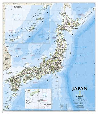
The signature Classic style map of Japan features a bright color palette with blue oceans and the country's terrain detailed in stunning shaded relief that has been a hallmark of National Geographic wall maps for over 75 years. The map includes thousands of place names, accurate boundaries, national parks, and major infrastructure networks such as roads, highways, airports, and railroads. Coastal bathymetry is shown with depth curves and soundings. Inset maps provide detail of Japan's Southern Outer Islands and the Ryukyu Islands. Information about the 2011 Tohoku earthquake and tsunami is included as well.
The map is encapsulated in heavy-duty 1.6 mil laminate which makes the paper much more durable and resistant to the swelling and shrinking caused by changes in humidity. Laminated maps can be framed without the need for glass, so the fames can be much lighter and less expensive.
- Map Scale = 1:3,115,000
- Sheet Size = 25" x 29"
PRP: 154.69 Lei
Acesta este Pretul Recomandat de Producator. Pretul de vanzare al produsului este afisat mai jos.
139.22Lei
139.22Lei
154.69 LeiPrimesti 139 puncte

Indisponibil
Descrierea produsului
The signature Classic style map of Japan features a bright color palette with blue oceans and the country's terrain detailed in stunning shaded relief that has been a hallmark of National Geographic wall maps for over 75 years. The map includes thousands of place names, accurate boundaries, national parks, and major infrastructure networks such as roads, highways, airports, and railroads. Coastal bathymetry is shown with depth curves and soundings. Inset maps provide detail of Japan's Southern Outer Islands and the Ryukyu Islands. Information about the 2011 Tohoku earthquake and tsunami is included as well.
The map is encapsulated in heavy-duty 1.6 mil laminate which makes the paper much more durable and resistant to the swelling and shrinking caused by changes in humidity. Laminated maps can be framed without the need for glass, so the fames can be much lighter and less expensive.
- Map Scale = 1:3,115,000
- Sheet Size = 25" x 29"
Detaliile produsului
De pe acelasi raft
-

PRP: 155.00 Lei
139.50 Lei
139.50 Lei155.00 Lei
-
PRP: 92.93 Lei
83.64 Lei
83.64 Lei92.93 Lei
-
PRP: 180.76 Lei
162.68 Lei
162.68 Lei180.76 Lei
-
PRP: 161.14 Lei
145.03 Lei
145.03 Lei161.14 Lei
-
PRP: 315.69 Lei
284.12 Lei
284.12 Lei315.69 Lei
-
PRP: 162.67 Lei
146.40 Lei
146.40 Lei162.67 Lei
-
PRP: 173.60 Lei
138.88 Lei
138.88 Lei173.60 Lei
-
PRP: 131.67 Lei
118.50 Lei
118.50 Lei131.67 Lei
-
PRP: 170.42 Lei
153.38 Lei
153.38 Lei170.42 Lei
-
PRP: 130.14 Lei
104.11 Lei
104.11 Lei130.14 Lei
-
PRP: 112.10 Lei
100.89 Lei
100.89 Lei112.10 Lei
-
PRP: 161.14 Lei
128.91 Lei
128.91 Lei161.14 Lei
-
PRP: 151.14 Lei
136.03 Lei
136.03 Lei151.14 Lei
