


Family Maps of Waushara County, Wisconsin
Family Maps of Waushara County, Wisconsin
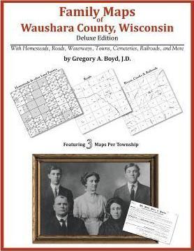
266 pages with 59 total maps Locating original landowners in maps has never been an easy task-until now. This volume in the Family Maps series contains newly created maps of original landowners (patent maps) in what is now Waushara County, Wisconsin, gleaned from the indexes of the U.S. Bureau of Land Management. But it offers much more than that. For each township in the county, there are two additional maps accompanying the patent map: a road map and a map showing waterways, railroads, and both modern and many historical city-centers and cemeteries. Included are indexes to help you locate what you are looking for, whether you know a person's name, a last name, a place-name, or a cemetery. The combination of maps and indexes are designed to aid researchers of American history or genealogy to explore frontier neighborhoods, examine family migrations, locate hard-to-find cemeteries and towns, as well as locate land based on legal descriptions found in old documents or deeds. The patent-maps are essentially plat maps but instead of depicting owners for a particular year, these maps show original landowners, no matter when the transfer from the federal government was completed. Dates of patents typically begin near the time of statehood and run into the early 1900s. What's Mapped in this book (that you'll not likely find elsewhere) . . . 3864 Parcels of Land (with original landowner names and patent-dates labeled in the relevant map) 43 Cemeteries plus . . . Roads, and existing Rivers, Creeks, Streams, Railroads, and Small-towns (including some historical), etc. What YEARS are these maps for? Here are the counts for parcels of land mapped, by the decade in which the corresponding land patents were issued: DecadeParcel-count 1840s2 1850s3256 1860s276 1870s127 1880s44 1890s90 1900s22 1910s6 1920s2 1930s3 1940s22 1950s2 1960s6 1970s2 1980s3 1990s1 What Cities and Towns are in Waushara County, Wisconsin (and in this book)? Auroraville, Bannerman, Borth, Brushville, Coloma, Dakota, Fountain Valley, Hancock, Heffron, Lohrville, Mount Morris, Pine River, Plainfield, Poy Sippi, Redgranite, Richford, Rodney (historical), Saxeville, Silver Lake, Spring Lake, Tustin, Wautoma, West Bloomfield, Wild Rose
PRP: 263.11 Lei
Acesta este Prețul Recomandat de Producător. Prețul de vânzare al produsului este afișat mai jos.
210.49Lei
210.49Lei
263.11 LeiPrimești 210 puncte
Livrare in 2-4 saptamani
Descrierea produsului
266 pages with 59 total maps Locating original landowners in maps has never been an easy task-until now. This volume in the Family Maps series contains newly created maps of original landowners (patent maps) in what is now Waushara County, Wisconsin, gleaned from the indexes of the U.S. Bureau of Land Management. But it offers much more than that. For each township in the county, there are two additional maps accompanying the patent map: a road map and a map showing waterways, railroads, and both modern and many historical city-centers and cemeteries. Included are indexes to help you locate what you are looking for, whether you know a person's name, a last name, a place-name, or a cemetery. The combination of maps and indexes are designed to aid researchers of American history or genealogy to explore frontier neighborhoods, examine family migrations, locate hard-to-find cemeteries and towns, as well as locate land based on legal descriptions found in old documents or deeds. The patent-maps are essentially plat maps but instead of depicting owners for a particular year, these maps show original landowners, no matter when the transfer from the federal government was completed. Dates of patents typically begin near the time of statehood and run into the early 1900s. What's Mapped in this book (that you'll not likely find elsewhere) . . . 3864 Parcels of Land (with original landowner names and patent-dates labeled in the relevant map) 43 Cemeteries plus . . . Roads, and existing Rivers, Creeks, Streams, Railroads, and Small-towns (including some historical), etc. What YEARS are these maps for? Here are the counts for parcels of land mapped, by the decade in which the corresponding land patents were issued: DecadeParcel-count 1840s2 1850s3256 1860s276 1870s127 1880s44 1890s90 1900s22 1910s6 1920s2 1930s3 1940s22 1950s2 1960s6 1970s2 1980s3 1990s1 What Cities and Towns are in Waushara County, Wisconsin (and in this book)? Auroraville, Bannerman, Borth, Brushville, Coloma, Dakota, Fountain Valley, Hancock, Heffron, Lohrville, Mount Morris, Pine River, Plainfield, Poy Sippi, Redgranite, Richford, Rodney (historical), Saxeville, Silver Lake, Spring Lake, Tustin, Wautoma, West Bloomfield, Wild Rose
Detaliile produsului


