


Massachusetts Trail Map: Mt. Greylock, Southwestern Massachusetts, Mt. Tom Reservation, and Skinner State Park and Mt. Holyoke Range
Massachusetts Trail Map: Mt. Greylock, Southwestern Massachusetts, Mt. Tom Reservation, and Skinner State Park and Mt. Holyoke Range
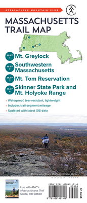
This full-color, topographic, waterproof Tyvek map is an indispensable resource for any hiker or backpacker setting out across the state of Massachusetts. Created by AMC's trusted cartography department using the latest GIS information, including cutting-edge LiDAR data, this fully updated map features trail-segment mileage and improved color coding. Covered areas include Mount Greylock, Southwestern Massachusetts, Mount Tom, and Skinner State Park and the Mount Holyoke Range. Printed on lightweight, waterproof, and tear-resistant Tyvek, this map is made to withstand many years of hard use on the trail and is the ideal upgrade to the paper maps that come with AMC's Massachusetts Trail Guide, 11th Edition.
PRP: 71.97 Lei
Acesta este Prețul Recomandat de Producător. Prețul de vânzare al produsului este afișat mai jos.
57.58Lei
57.58Lei
71.97 LeiPrimești 57 puncte
Indisponibil
Descrierea produsului
This full-color, topographic, waterproof Tyvek map is an indispensable resource for any hiker or backpacker setting out across the state of Massachusetts. Created by AMC's trusted cartography department using the latest GIS information, including cutting-edge LiDAR data, this fully updated map features trail-segment mileage and improved color coding. Covered areas include Mount Greylock, Southwestern Massachusetts, Mount Tom, and Skinner State Park and the Mount Holyoke Range. Printed on lightweight, waterproof, and tear-resistant Tyvek, this map is made to withstand many years of hard use on the trail and is the ideal upgrade to the paper maps that come with AMC's Massachusetts Trail Guide, 11th Edition.
Detaliile produsului


