


Ecuador and Galapagos Islands
Ecuador and Galapagos Islands
- Waterproof - Tear-Resistant - Travel Map
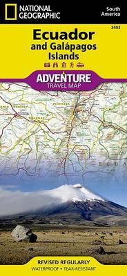
National Geographic's Ecuador and Galapagos Islands Adventure Map, with its comprehensive information, is uniquely designed for adventure travelers. The map delivers unparalleled detail of the entire country and its recreational, historical, cultural and natural destinations. Pinpointed spots include beaches, wildlife areas, archeological sites, churches and areas for camping, surfing, fishing and diving. A list of cities and towns with a user-friendly index is provided along with a road network of highways, major and secondary roads, shown with distances. Unsurfaced and 4-wheel-drive roads are mapped for those wishing to get off the beaten track. Other displayed travel aids include airports, airfields, harbors, anchorage sites, railroads, ferry routes and border crossings with neighboring Colombia and Peru.
The northern part of the map covers the capital city of Quito, Cotopaxi Volcano and National Park, Cuyabeno Wildlife Reserve, the town of Tena in the Amazon rainforest and the country's largest city of Guayaquil. The southern part of the map covers from Guayaquil to the southern and southeastern border with Peru, showing the diverse Podocarpus National Park in the southern Andes and Amazonian ecological systems. An inset map covers the world renowned Galapagos Islands, showing Galapagos National Park and Marine Reserve, Tortoise Reserve and diving areas around the islands. This expertly researched map is the perfect complement to any guidebook.
Every Adventure Map is printed on durable synthetic paper, making them waterproof, tear-resistant and tough -- capable of withstanding the rigors of international travel.
- Map Scale = 1:750,000
- Sheet Size = 37.75" x 25.5"
- Folded Size = 4.25" x 9.25"
PRP: 108.14 Lei
Acesta este Pretul Recomandat de Producator. Pretul de vanzare al produsului este afisat mai jos.
97.33Lei
97.33Lei
108.14 LeiPrimesti 97 puncte

Indisponibil
Descrierea produsului
- Waterproof - Tear-Resistant - Travel Map
National Geographic's Ecuador and Galapagos Islands Adventure Map, with its comprehensive information, is uniquely designed for adventure travelers. The map delivers unparalleled detail of the entire country and its recreational, historical, cultural and natural destinations. Pinpointed spots include beaches, wildlife areas, archeological sites, churches and areas for camping, surfing, fishing and diving. A list of cities and towns with a user-friendly index is provided along with a road network of highways, major and secondary roads, shown with distances. Unsurfaced and 4-wheel-drive roads are mapped for those wishing to get off the beaten track. Other displayed travel aids include airports, airfields, harbors, anchorage sites, railroads, ferry routes and border crossings with neighboring Colombia and Peru.
The northern part of the map covers the capital city of Quito, Cotopaxi Volcano and National Park, Cuyabeno Wildlife Reserve, the town of Tena in the Amazon rainforest and the country's largest city of Guayaquil. The southern part of the map covers from Guayaquil to the southern and southeastern border with Peru, showing the diverse Podocarpus National Park in the southern Andes and Amazonian ecological systems. An inset map covers the world renowned Galapagos Islands, showing Galapagos National Park and Marine Reserve, Tortoise Reserve and diving areas around the islands. This expertly researched map is the perfect complement to any guidebook.
Every Adventure Map is printed on durable synthetic paper, making them waterproof, tear-resistant and tough -- capable of withstanding the rigors of international travel.
- Map Scale = 1:750,000
- Sheet Size = 37.75" x 25.5"
- Folded Size = 4.25" x 9.25"
Detaliile produsului
De pe acelasi raft
-

PRP: 154.93 Lei
139.44 Lei
139.44 Lei154.93 Lei
-
PRP: 161.14 Lei
145.03 Lei
145.03 Lei161.14 Lei
-
PRP: 77.11 Lei
69.40 Lei
69.40 Lei77.11 Lei
-
PRP: 239.70 Lei
215.73 Lei
215.73 Lei239.70 Lei
-
PRP: 37.13 Lei
33.42 Lei
33.42 Lei37.13 Lei
-
PRP: 179.74 Lei
161.77 Lei
161.77 Lei179.74 Lei
-
PRP: 61.06 Lei
54.95 Lei
54.95 Lei61.06 Lei
-
PRP: 177.86 Lei
160.07 Lei
160.07 Lei177.86 Lei
-
PRP: 117.74 Lei
105.97 Lei
105.97 Lei117.74 Lei
-
PRP: 124.95 Lei
112.45 Lei
112.45 Lei124.95 Lei
-
PRP: 215.79 Lei
194.21 Lei
194.21 Lei215.79 Lei
-
PRP: 198.09 Lei
178.28 Lei
178.28 Lei198.09 Lei
-
PRP: 95.06 Lei
85.55 Lei
85.55 Lei95.06 Lei
-
PRP: 123.94 Lei
111.55 Lei
111.55 Lei123.94 Lei
-
PRP: 120.43 Lei
108.39 Lei
108.39 Lei120.43 Lei
-
PRP: 149.75 Lei
134.78 Lei
134.78 Lei149.75 Lei
